I’m looking at the April 1961 issue of Road & Track (“the motor enthusiasts’ magazine”) which I bought when I was twelve. Above the cover photo, a time-lapse shot of the ocean-front highway in nighttime Santa Monica (white and red streaks denoting the relentless stream of head and tail lights), is a bold red headline: “OUR ENEMY THE AUTOMOBILE by VICTOR GRUEN.” Inside, the urban planner and architect who fathered the indoor suburban shopping mall as well as its antidote, the downtown pedestrian mall, bemoans the auto-centric priorities of his fellow planners, whom he calls “autocrats”:
They accept automobile traffic in the same manner that former heathen religions accepted elementary phenomena like the sun and the rain, thunder and earthquakes — as superior elementary forces with which man cannot assume to tangle.
He quotes a contemporary proposed revision of the New York Zoning Resolution which would realign planning priorities of New York City (of all places) “…by paying deference to the automobile.” He notes that while the daily number of private car visitors to Manhattan increased by 171,000 over an 8-year period, the overall number of visitors decreased by more than twice that…and in case the reader misses the implications for business, he quotes a 4-year study of the Chicago Loop in which 55 percent more people enter the Loop by private car in the last year than in the first, and in which the decline in business at State St. department stores (16.3 percent) neatly tracks the drop in public transport users (13.2). He recommends a planning alternative based upon the notion of human “activity cells” as islands of commerce and culture, separated by green landscaped zones and served by multi-modal transportation. Gruen relies on various forms of public transportation to get people to these islands, with large urban centers restricting cars to perimeter roads with parking nodes to serve the transition to public transport. He doesn’t make much of a fuss over bicycles, but he was writing this a good decade before the bike boom of the 70s.
The Visionary
Despite the fact that few of his ideas for pedestrian malls had been tried when Gruen appeared in Road & Track (Boulder’s Pearl Street Mall, for example, wouldn’t come along for another 16 years), he predicts that most of them will fail. He foresees that pedestrian malls will be employed mostly as one-shot panaceas for downtown revival (like “one-way streets, bargain days and parades”), rather than as part of a larger, planned environment involving expanded public transport, belt roads around downtown cores, satellite parking nodes and coordinated landscape design, all supported by mixed-use zoning. And in fact, some of the best-intentioned pedestrian experiments (like the Lake Street mall in Oak Park, Illinois) did fail in the decades after Gruen made this prediction. For shelling out 50 cents, then, a 12 year-old aspiring to be an architect/planner got a provocative glimpse of the future. All he had to do was turn to page 18 to read Gruen’s article.
A Detour to Kick Some Tires
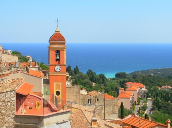
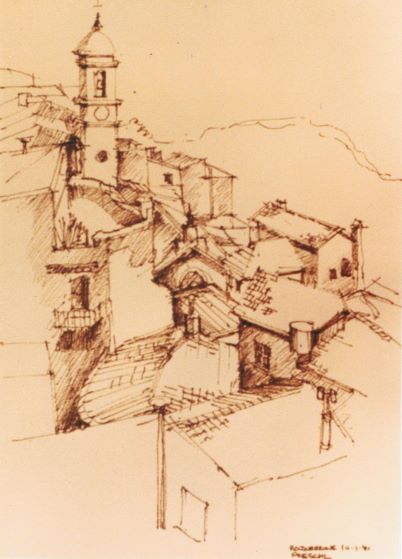
But instead your correspondent went directly to page 63, where a slinky French Delahaye Type 235 revealed its mysteries. By 1961, this car was already considered a classic, and it reminded me of some of the cars I’d seen when walking with my dad down Chicago’s automobile row, where we first encountered the then-new Mercedes 300SL Gullwing (a road-going space capsule named for its tiny, upward-opening doors), an elderly Hupmobile still in use as everyday transport, and a classic Depression-era Cord 810 sitting disconsolately on a dusky, used car lot. The Delahaye, like that Cord, seemed not so much a car as an insinuation rendered in metal. Its swoopy art moderne fenders, intimate cabin, and louvered, aristocratic prow implied a life spent wafting down empty, tree-lined byways in an era when cars were mostly for the bourgeoisie, an era which was long over when the last Delahaye was built in 1954. By 1970, when I started my year in Paris as an architecture student, gasoline was 3 times as expensive as in the U.S., tiny cars like the Fiat Topolino (mouse) and original Mini held a big share of the market, and most Parisians used the extensive Metro system of subterranean trains for intra-city transit. This was a pattern repeated in other European cities I visited; urban densities and the availability of cheap, effective public transport (and the comparatively expensive routine of fueling and parking a car) meant that inside the city you abandoned the car. It was during my student year in Europe that I started having dreams about what I eventually called the “magic city.” Somehow, animated street scenes and corner-of-the-eye glimpses of Chicago, Paris, Stockholm, Copenhagen, Amsterdam and Florence had formed into an urban dreamscape with its own Escher-like logic and continuity. Walking through the magic city was like inhabiting a Piranesi sketch: streets passed over other streets, spanned rivers on arcaded bridges, and everywhere provided shady vantage points from which to appreciate the inner life and mysterious workings of something called “place.” When I first stumbled upon Roquebrune, clinging to stony cliffs above the Mediterranean, I thought I’d walked into someone else’s ancient dream of the magic city.
Magic City # 1: Roquebrune
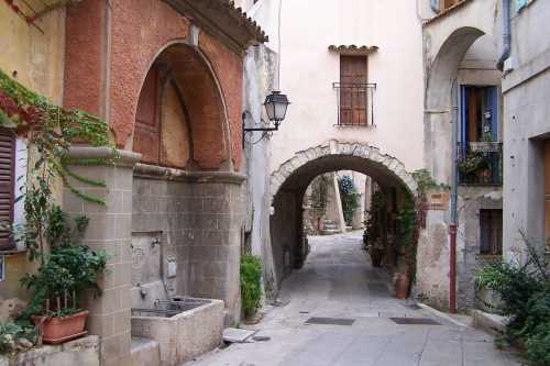
I encountered Roquebrune a few years before my 1977 move to Boulder, which coincided with the inaugural year of the Pearl Street Mall. So it wouldn’t have occurred to me back in 1974 that here was a terraced, Piranesian version of the Pearl Street Mall. In fact, here was a whole pedestrian town. You left your car in a lot at the town’s periphery and it revealed its mysteries and surprises along streets that meandered into squares and courtyards, turned into stairways or bridges, in a rhythm that played with ideas of closed and open, dark and light, paved and green. Nobody living in Roquebrune would have been aware that this was an example of “mixed-use” zoning, because in ancient hill towns like this there had never been anything other than a mix of uses; there were no “bedroom communities” in Provence. In America, particularly once you ventured
west of the heartland, cities became less pedestrian-friendly, and the urban planning story was about big distances, cheap land, cheap fuel and scanty public transport. I first began to wonder about the implications of this when walking with my dad in a then-new “bedroom community” in Whittier, CA in 1957 or ’58. For me, the place allowed wide-eyed immersion in the automotive culture of Los Angeles (our neighbors had matching Alfa Romeos); for my dad, it was just his Kaiser Aluminum year. We were walking on the road (there were no sidewalks), heading home past cul-de-sacs lined with drowsy, single-story ranchburgers after checking the sunset over one of the rapidly-vanishing orange groves. A police car pulled up even with us and the officer asked my dad, “Is something wrong, sir?” My dad answered, “No, nothing’s wrong. We’re just taking a walk. We just moved here from Chicago.” The officer paused a minute before answering that he could have guessed we were from somewhere else, because people out here didn’t “just take a walk.” From my third-grader perspective, driving looked like it saved lots of time, which “taking a walk” with my dad seemed deliberately designed to idle away, and it seemed cheap, too. How cheap was it? Let’s page through that Road & Track from half a century ago.
Almost Cheaper than Taking the Trolley
In 1961, the median annual income was about $4,100. A new VW Beetle was $1,595. A gallon of gas was 19 cents including tax, and a cheerful station attendant would pump it for you and then clean your windshield. If you weren’t worried too much about using more of that gas, you could spend about $1,000 more than a Beetle and get a Chevy Impala, the most popular domestic car that year. The availability of cheap gas and cheap, mass-produced cars fueled the growth of suburbs and the expansion of shopping malls as well as the consumer culture that went with them. In 1961 the baby boom still had four years to run, and the flight from city centers to the suburbs was an established national pattern. And if you couldn’t afford a new car, you could easily get a clean, reliable used one for $500. One bargain in the Market Place section of Road & Track that April was the show-quality 1941 Lincoln Continental V-12 coupe. For only $950, you could have a twin of the car that Bogie and Bacall aimed into the night in “The Big Sleep.” Driving seemed cheaper than taking the train or the trolley.
By the Way, What Happened to That Trolley?
It disappeared along with the corner store during the postwar explosion of suburbs. In exiting the urban stage, trolley and streetcar lines got a push from some automobile and oil companies. In 1949 GM and other companies were indicted under provisions of the Sherman Anti-Trust Act for conspiring to dismantle urban trolleys through its purchase of a network of linked holding companies, including National City Lines and Pacific City Lines. GM was convicted on only one count of the charges, and paid a nominal fine. If you’ve seen the animated film “Who Killed Roger Rabbit?” you’ve heard this story before. In the decade that followed, while we huddled in our living rooms watching the Twilight Zone, the focal points of our lives drifted further away from city centers, we lost most of our trolleys and streetcars, and our houses lost their front porches, an architectural change prompted as much by the popularity of television and air conditioning as by the growth of auto-centric suburbs.
After the Oil Shock: Victor Gruen’s Pedestrian Mall Model
It’s probably not a coincidence that most of the pedestrian mall experiments that Victor Gruen and like-minded planners had encouraged were realized after the first oil shock of 1973 and ’74. When the Pearl Street Mall was inaugurated in 1977, gas lines were a recent and unpleasant memory. Beyond the sudden increase in the cost of driving, other forces encouraging this development included the rise of the historic preservation movement, the increasing popularity of jogging and biking, and the attention given to human-scaled features and the more relaxed pedestrian pace in books which drew the attention of planners during this period, including Christopher Alexander’s A Pattern Language and Gordon Cullen’s Townscape. Gruen turned out to be prescient regarding many of these mall experiments, as the pedestrian streets were not supported with the public transport, perimeter parking and (perhaps most important) mixed-use zoning he’d envisioned. We might be getting shoppers to come back for a stroll through our downtowns, but we weren’t yet persuading people to move back downtown. Those urban planning strategies would await another oil shock, and would be enacted dramatically in a couple of already-vibrant cities.
Magic City #2: Le Viaduc des Arts, Paris
By the end of the 1980s, well after the second oil shock, lots of neighborhoods in European and American cities had entered their post-industrial phase, a consequence of a trend toward concentrating high technology development and design in the home country, but moving production offshore to Asian or Latin American sites, or to the former Eastern Bloc countries when these became receptive. This left a bounty of vacant factory and warehouse buildings to be reclaimed and repurposed. The historic preservation movement, by now a vital force in most of these cities, encouraged the view that these old buildings constituted urban civilization’s most valuable under-utilized resource, and it became chic to renovate an old warehouse or factory as new living space, shops, or better still, as “live-work” space.
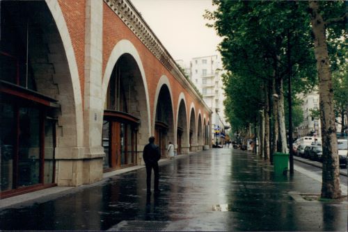
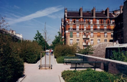
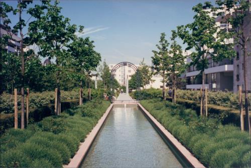
After the factories and warehouses, urbanists began to eye some of the other abandoned infrastructure, such as railroad bridges and viaducts, and began to create schemes for using these to create new links between neighborhoods, and also between different spatial levels of a neighborhood. I happened upon one of the first successful products of this search when in the neighborhood of the Place de la Bastille, in 1997. The Viaduc des Arts and its second level, the Promenade Plantee, repurpose an abandoned brick and stone railroad viaduct as a series of galleries, artisan shops, cafes and restaurants, supporting (structurally and metaphorically) a linear 2nd level urban park with new housing and pedestrian links to the surrounding neighborhoods, and both culminate in a spectacular, green bowl-shaped park surrounded by old and new apartments, shops and cafes. When I first laid eyes on Le Viaduc, it occurred to me that somebody else had been having the same recurring dream about the magic city, but they’d taken action and built one. The architects (Berger and Galliano for the Viaduct, Mathieux and Vergely for the Promenade) had succeeded in transforming a forgotten corner of the city into a magnetic attraction.
I returned to it two more times during my brief stay in Paris.
Magic City #3: The High Line, New York
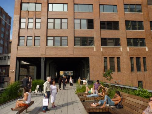
The Friends of the High Line, an abandoned elevated rail line running through Chelsea and the Meatpacking District, were inspired by the success of the Promenade Plantee to press forward with their idea of an elevated pedestrian park. They’d formed in 1999 with the goal of preventing the structure from being demolished, then sponsored an international invitational for design ideas in 2003. The CSX Company donated the first two half-mile sections to the city in 2005, and the first section of the park opened in June 2009, with a full mile of park operating as of spring 2011. Like the Parisian project, the High Line serves neighborhoods which already have highly developed mass transit, so its designers (landscape architect James Corner and architects Diller Scofidio + Renfro) could concentrate on providing a memorable series of pedestrian spaces and vistas which serve to provide a respite from the pace and congestion below, while still conveying the excitement and vitality of the surroundings. Also similar to the Promenade is the way structures like the Standard Hotel cross over the park level and offer access to it.
In fact, a few more of these physical connections would probably increase the attractiveness of the High Line when it is finally complete. A large yellow sign posted at the sundeck over Tenth Avenue advises, “The sooner you park your car, the sooner you can stop thinking.”
Implications for Boulder
Unlike Paris and New York, Boulder lacks abandoned architectural and engineering works of such heroic scale. But it seems to be participating in the collapse of the shopping mall model, and that (like the 1990s boom in retail centers) is a phenomenon of heroic scale. We now have nearly 50 square feet of retail space for every man, woman and child in the country. That’s 14.2 billion square feet of retail space. The national vacancy rate for shopping malls is over 9 percent, while for strip malls it’s over 11 percent. So, we have almost one and a half billion square feet of vacant retail space, some of it entombed in malls and strip malls which are entirely abandoned. One of the striking aspects of our 29th Street Mall is what a missed opportunity it was to create a truly involving pedestrian experience and to offer a real mix of activities and uses along its “streets.” After a lot of talk (and some earnest effort) surrounding innovation and a new urban vision, what we got is, in essence, a decorated parking lot, too much corporate Mall and not enough people-oriented Street. It’s an acceptable place to buy a tee shirt or a quick lunch, but you don’t amble down 29th in the relaxed way you can on Pearl because it’s not a pedestrian street. If you’re looking for the local equivalent of the magic city, you’ll be happier on Pearl Street, even on a slow day when the buskers have all gone home. Perhaps the current economic depression, with its attendant vacant acreage in the built environment, will give planners and developers just the impetus they need to embrace truly innovative solutions, finding new ways to live with higher densities and realizing that just providing endless parking is not a substitute for real urban magnetism in making commercially viable spaces. It’s still true that the most valuable, underutilized urban resource we have is our existing stock of old buildings. We need, somehow, to find ways to integrate these familiar features of our surroundings into a vision that will create new links between neighbors as well as neighborhoods, and invite new participants into the lives of our towns.
Sources and credits:
Road & Track, April 1961: “Our Enemy, the Automobile” by Victor Gruen.
Retail space in the United States: International Council of Shopping Centers Website and National Public Radio broadcast, 2010. I used the more conservative figures from ICSC.
Failure of shopping mall model + vacancy figures: Mike Shedlock of Sitka Pacific Capital Management, writing on the economic prospects of shopping malls in an article on the blog http://globaleconomicanalysis.blogspot.com. His vacancy figures for shopping malls and strip malls are based upon the top 80 U.S. markets and were posted on “theworldnet.info” website April 7, 2011.


