The Jefferson County Commissioners have asked the City of Boulder and Boulder County to drop their long-standing opposition to the proposed Jefferson Parkway by January 31, in exchange for which JeffCo will put up $5 million toward the purchase of “Section 16,” a 640-acre piece of land along Hwy 93 at the southwest corner of the Rocky Flats site. Boulder City and County’s piece of the deal would be to come up with another $5 million so Section 16 could be purchased and designated as open space that would be contiguous on the west with existing foothills open space and on the east and north with what is now the Rocky Flats National Wildlife Refuge.
Preserving Section 16 as open space would establish open-space continuity between the foothills open space and the wildlife refuge, providing an assured corridor for passage of wildlife. But it would also protect this key piece of land from urban sprawl of the sort manifest nearby in the Candelas development slated for a four-mile swath of land across the southern border of the Rocky Flats site (see the map below).

The yellow arrows point to Section 16. The dotted red line indicates the route of the proposed Jefferson Parkway. The Candelas project is the cross-hatched area. From http://www.boulderblueline.org/2010/11/21/jefferson-parkways-layers-of-complication/ (click to view larger)
In the two weeks remaining in this old year the Boulder City Council and Boulder County Commissioners must decide whether to accept or reject the JeffCo proposal. Saving Section 16 for open space would be a real gain, but it’s not worth the price of making Boulder City and Boulder County neutral regarding the Jefferson Parkway. Why? Because for the Jefferson Parkway to be constructed along the eastern edge of the Rocky Flats site as planned raises public health and environmental concerns on which the voices of officials of the City of Boulder and Boulder County will be needed. This is not the time for them to duck their responsibility on the Parkway issue.
The act of Congress that turned most of the site of the former Rocky Flats nuclear bomb factory into the Rocky Flats National Wildlife Refuge set aside for possible future highway development a 300-foot wide strip along the eastern boundary of the Rocky Flats site. As the map above shows, this strip is the preferred alignment for the Jefferson Parkway.
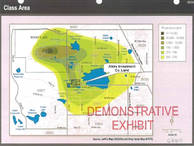
The eastern side of the site of the now defunct Rocky Flats nuclear bomb factory is the predominantly downwind, most contaminated portion of the site. After a major fire at Rocky Flats in 1969, independent scientists found high concentrations of plutonium in off-site soil east of the plant. Two specialists from the Atomic Energy Commission (predecessor to the Department of Energy), on the basis of their own sampling, produced a map showing gradations of plutonium contamination in the environment around Rocky Flats. According to their map (see below), about 30 square-miles of off-site land were contaminated with plutonium released from Rocky Flats. The proposed Jefferson Parkway passes through the heart of this area.
The spatial distribution of plutonium contamination from Rocky Flats in becquerels (one becquerel equals one disintegration or burst of radiation per second) is shown in the figure below. The original version of this map was prepared by P. W. Krey and E. P. Hardy of the Health and Safety Lab of the Atomic Energy Commission and was published in their 1970 report, “Plutonium in Soil Around the Rocky Flats Plant,” HASL 235. This adaptation of their map was used to delineate the area of the class of affected property owners seeking compensation for damage to their property in the Cook v. Dow & Rockwell lawsuit heard in Denver federal court and decided against the corporations in February 2006, a verdict reversed by the Appeals Court in September 2010. The case seems likely to go to the Supreme Court. The Alkire Investment Land indicated on the map was property on which the owners claimed loss of value.
The principal product of the Rocky Flats plant was the explosive plutonium “pit” at the core of every nuclear warhead in the US nuclear arsenal. From the beginning of production in 1952 until it ended in 1989 tiny plutonium particles were released to the environment by fires, accidents and routine operations. Minuscule particles were distributed near and far by the wind common at the site.
Plutonium emits a type of radiation that cannot penetrate skin but that may induce cancer or other ailments if it is inhaled or otherwise taken into the body. In 1997 researchers at Columbia University reported that a single plutonium particle lodged in the body could initiate cancer. A 2006 National Academy of Sciences study on low-dose radiation exposure concluded that any exposure is potentially harmful. Plutonium-laden dust is especially dangerous. Particles too small to see are not too small to do harm. Because plutonium remains radioactive for hundreds of thousands of years, its presence in the environment presents an essentially permanent danger.
A recent citizen sampling project sponsored by the Rocky Mountain Peace and Justice Center found hot particles with high concentrations of plutonium in crawl space at a house near Standley Lake about one mile southeast of the Rocky Flats site. If plutonium is present in dust at one house in the known contaminated area it is very likely present in dust in other dwellings, schools, businesses or shops in the area. We believe the DOE should collect dust samples and analyze them for plutonium for any who request it for structures within the known contaminated area, and that the DOE should also monitor the health of affected people who request it. To date, the DOE has responded to neither of these recommendations. But we can make such recommendations only because there’s evidence that the off-site area downwind of Rocky Flats is still contaminated.
Likewise, the Rocky Flats site itself is still contaminated. Those responsible for the “cleanup” that preceded transfer in 2006 of most of the site to US Fish & Wildlife Service to operate as a wildlife refuge made no effort to clean the site to the maximum extent possible with existing technology. Indeed, part of the logic of turning the site into a wildlife refuge was to reduce the cost of the “cleanup.” An unknown quantity of plutonium in particle form was deliberately left in soil on the site.
The “cleanup” was driven primarily by cost but also by the assumption that plutonium left in the Rocky Flats environment will remain “relatively immobile.” This “relatively immobile” conclusion was based primarily on computer modeling rather than direct observation. An environmental engineer using instruments set up in the field on the site had detected real-time significant migration of plutonium in subsurface soil in the unusually wet spring of 1995; those who designed the cleanup ignored his finding. They also ignored a 1996 study that showed that the 18 species of burrowing animals present at Rocky Flats are constantly redistributing soil and its contents. According to a wholly unpredictable timeline, they bring buried material up and take surface material down, making particles of plutonium available to be picked up by wind and carried elsewhere. Not only is the Rocky Flats site still contaminated; it persists as an active source of airborne plutonium particles.
Alan Boles pointed out in his very informative December 13 Blue Line article on the Jefferson Parkway that the attempt to build what was formerly called W-470 was put to a vote in 1989 and defeated by a margin of 4-to-1. A key reason for the opposition was the environmental contamination and concern that constructing the highway on or near Rocky Flats would stir up clouds of plutonium-laden dust with all the attendant danger.
The area at or near Rocky Flats intended for the Parkway is still contaminated and thus is still likely to stir up plutonium-laden dust should highway construction ensue. Isn’t it the case that preparation of an Environmental Impact Statement (EIS) for the Parkway project will bring the public health and environmental issues to the fore?
Were the Parkway to be built with federal funding, an EIS would be required. But the Parkway is now a wholly private endeavor. No government funds will be spent. Privatizing an endeavor that will have a large public impact may mean that the EIS process can be bypassed because it is not legally required. Both the City of Boulder and Boulder Country need to be in a position to demand that an EIS be done on the Jefferson Parkway. For this and related reasons, both entities should reject JeffCo’s well-larded invitation that they surrender their opposition to the Jefferson Parkway.
D-Day – Decision Day – is at hand. The Boulder City Council will respond to the JeffCo overture on December 21, their final meeting of the year. Commissioner Will Toor tells me this item will be on the agenda of the Boulder County Commissioners’ business meeting that begins at 10:30 AM that same day, Tuesday, December 21. Residents of the city and county should certainly make their views known.


 (9 votes, average: 4.78 out of 5)