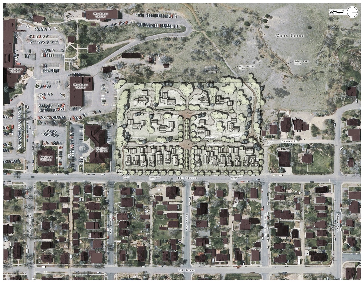
The Boulder neighborhood group Friends of Mt. Sanitas would like you to know that once again, the former Boulder Junior Academy property at 2641 4th St. is facing a new round of changes. Tucked against the base of the Mt. Sanitas trailhead on Boulder’s west side, the 5.84-acre site has been the focus of at least three development proposals since 2004. Its latest purchaser, developer Chris Foreman of Moonbeam LLC, and his architects, Surround Architecture, recently submitted concept plans for 23 new houses to the City of Boulder Planning Department for review. You can see the site plan and project updates at www.moonbeamboulder.com and full concept plan documents at the city’s website. You can also view detailed city staff comments at the Friends of Mt. Sanitas website.
Next up for the proposal: public comment and review by the city Planning Board, March 15th at 6:00 pm in the City Council Chambers, Municipal Building, 1777 Broadway.
Friends of Mt. Sanitas has followed proposed development on the site since 2004. We gather and distribute information about this special bit of Boulder, and encourage active public participation in the planning of its future. Here’s our take on the Concept Proposal and what it means for our neighborhood.
4th Street Row
Our top concern is the placement of 15 houses cheek-by-jowl facing east along 4th Street. Under RL-1 zoning, the minimum lot size is 7,000 sq. ft.; the current proposal, however, calls for uniform lot sizes which are significantly narrower and shorter (37 x 100 ft) resulting in a wall of houses which denies visual permeability to the site, an established criteria of the Planning Board. Friends of Mt. Sanitas advocates for lots and setbacks that approximate surrounding housing patterns, resulting in eight to nine homes where 15 are planned. The immediate area enjoys a pleasing variety of house and lot sizes, while the proposal has a decidedly dense, high-intensity, urban feel, very much out of character with the Historic District to the south and adjacent neighborhoods to the north and east. We are pleased that planning staff comments reflect these concerns as well.
Site Density
Overall, the density of the site is calculated at four units per acre, which is in keeping with the neighborhood. But the plan has front-loaded the density along 4th Street, with approximately two acres carrying 15 units, or 7.5 units per acre, much higher than the surrounding neighborhood. We recommend the plan relieve this density by distributing six to eight houses into the back zone, which currently calls for only eight one-half acre lots.
Traffic
While the submitted plan cites a past traffic load for the former school of 372 trips per day, this calculation is based on standard assumptions, not actual use. The now-demolished school didn’t operate at full capacity for years, and even while it did many students walked or carpooled, generating few trips to the site. The claim that the site will generate roughly half the car trips of the previous use is simply disingenuous. More relevant: 200+ new trips per day after development.
Construction
Developer Foreman’s team plans to design and build the houses along 4th Street and sell the large back lots for individual development. Design guidelines would be provided for all homes. Typically the city grants three years for a project of this size to be completed, though extensions have been liberally granted during the economic downturn. Plans call for extensive regrading with some material leaving the site. Construction impact on the neighborhood will be considerable, and we advocate a tight construction timeline and particularly strict oversight of the cut and fill phase.
Parking and Site Access
Parking plans submitted call for two-car garages for all 23 homes, with limited additional parking throughout the site. City staff comments express concern about whether this will be adequate for the neighborhood, and Friends agrees. With inevitable drop-ins and ongoing visitor parking needs for the Mt. Sanitas trailhead, we recommend the city insist on options to provide adequate parking on and off the site. With only one access point into the site, Friends also assumes the development team will follow city direction to improve proposed site access and circulation.
Water Rights
The site comes with water rights to the Silver Lake Ditch, a portion of which will be negotiated with the city. We wouldn’t be surprised if this becomes a contentious issue with existing ditch rights holders.
Action
Friends of Mt. Sanitas believes this small, unique piece of our city should be an example of the best Boulder can do. By insisting on the highest standards of concept, creativity, and execution, our neighborhood can show respect for a place we love and visit hundreds of times each week.
Email or mail your comments and concerns to the Planning Board prior to the March 15th meeting, or plan to speak if you can. Public participation is always welcome!
Contact: City of Boulder Planning Board boulderplanningboard@bouldercolorado.gov
To join our mailing list, go to www.mtsanitas.org and subscribe.


